Hiking in Hong Kong
Hong Kong is home to hundreds upon hundreds of kilometres of hiking trails. The vast majority of these hiking trails barely even get a look from visitors. In many ways this is a blessing. On the weekends Hong Konger’s jump on buses, boats and trains as they had out to the territories rural areas to escape the city centre. Many believe that Hong Kong is the worlds best city for hiking, and from our experiences it would be hard to disagree. In addition to this article, we also have one on hiking Lantau Peak. Do be aware that Hong Kong is both very hot and very humid, so plan accordingly.
What is the Maclehose?
For those who are unfamiliar, the maclehose trail is a 100km trial divided into 10 stages that crosses the new territories from Sai Kung in the east to Tuen Mun in the west. It really is one of Hong Kong’s premier hiking trails. Taking in some of the most spectacular scenery this beautiful city has to offer.
There is a fantastic blog that we’ve utilised for many hikes in Hong Kong. This site provides detailed information on how to get to and from almost all of the major trails in Hong Kong.
We took on stages 1 and 2 of the maclehose on a hot autumn Sunday in October. Sunday is probably the best day as you can take the 96R direct from Diamond Hill MTR to Pak Tam Chung. The other 6 days of the week you need to take a bus to Sai Kung and then transfer. Travel from Kowloon (on a Sunday) takes approximately 1.5 hours depending on traffic. You don’t want to start too late, as the last bus from Pak Tam Au, the trails end, is at 19:30. Although you don’t have to worry about the buses if you do what we did and skip the last 1.5 hours of stage 2 and take a “deluxe” speedboat back from Sai Wan to Sai Kung.
From the Pak Tam Chung bus stop, head out to the road and take a left and then follow the road until you a sign indicating the start of the trail. From then on you can follow the wooden posts marked M001, M002 etc. If you want to be extra sure, you can download maps.me which is an amazing offline map app. Be sure to download the map for HK beforehand though. I cannot recommend this app enough. It has taken us through the Mandalay countryside, Hong Kong’s peaks and the wilderness of Hokkaido.
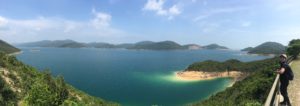
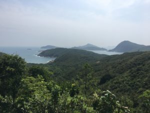
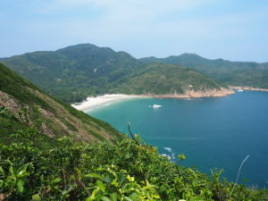
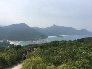
Stage 1 is pretty easy, save for a few uphill sections. The scenery is wonderful, but stage 2 just blows all that out of the water. Easily one of the most stunning hikes we have done. We comfortably completed stage 1 in about 2.5 hours and started stage 2 around 1 o’clock. Its was at this point we began to slow. Stage 2 has a few fairly tough parts that we were tackling in sweltering weather.
After walking down to Long Ke beach, about 2km into the second stage, we had about a quarter of a litre of water left. Info online had told us you could buy water at Long Ke, however this not correct. So we walked the next 5km or so rationing tiny mouthfuls of water knowing there were shops at Sai Wan. This included pretty rough climb up to the top of Sai Wan Shan in the stifling October heat and humidity. As frustrating as this was, we should’ve been better prepared.
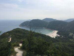
However the views made the headache and dry scratchy throat worthwhile. As we walked a well trodden path towards San Wan it seemed unbelievable that we were only 45 minutes from downtown Hong Kong. Truly remarkable. Sadly this is a side of this city that few travellers ever see.
As the pass sloped down towards Sai Wan beach we were greeted with the welcome sight of a fridge full of water. After parting with more than you would want to pay for a couple of bottles we settled down to rest our legs at Sai Wan. We were hot, dirty and dehydrated. So when we came across the option of a “deluxe” boat back to San Kung, it seemed far more appealing that another 5kms of hiking.
With no pier to speak of we waded out to our knees and hopped into a little speedboat that fitted no more than 20 people. Within a few minutes we were hitting 2-3 metre swells that were throwing us out of our seats. Each time a new wave came the front of the boat would peak out over the crest, unknowing if there would be anything to catch it when gravity came into play. If there was nothing to catch us, gravity brought us back down with an almighty thud and short flight from out seats.
After about 15 minutes we left the rough seas and entered the sheltered bays that lead to Sai Kung. Here we were able to catch a wonderful view of the landscape we’d just hiked across. The entire journey around the Sai Kung peninsula only took 30 minutes. We would recommend it to anyone who finds themselves in this little corner of north east Hong Kong. Although we weren’t able to finish stage 2 of the Maclehose, the ride back to Sai Kung was worth it.
Would we do it differently?
Yes and no. The boat journey back was amazing and would not have been possible if we’d completed the hike. We’d definitely like to head back and complete stage 2 for sure. However we really enjoyed experience and weren’t too disappointed about not completing stage 2. We probably would have started an hour earlier than we did if we were to go back and do it again.
How did we get there?
Check the website at the top for more details, but we went on a Sunday. This meant we could take 96R direct from Diamond Hill to Pak Tam Chung. When you arrive at Diamond Hill, follow the signs to the bus terminus, enter it and turn left. Walk forward approximately 200m and you will see the signs for it on your right. You can take a taxi, but it will be pretty expensive. From Tsim Sha Tsui it took us around 1.5 hours to get to Pak Tam Chung.